Last October, ahead of the 2019/20 boreal winter, I wrote about simulating the North Atlantic eddy-driven jet stream as well as midlatitude storm activity and precipitation across the North Atlantic and Europe in a global climate model. In a recent paper, my colleagues and I examined how the representation of these phenomena improves when the atmospheric resolution of one climate model is increased—with the potential to boost the trustworthiness of future projections. In a new paper published in Journal of Geophysical Research: Atmospheres, led by Margot Bador of the University of New South Wales’ Climate Change Research Centre, extreme precipitation was examined globally, and in greater detail, across six current-generation climate models.
Increasing global climate models’ resolution is expected to improve simulated daily precipitation extremes because high-resolution models are better able to represent weather. To test this hypothesis across a range of models, pairs of low- and high-resolution forced (i.e., atmosphere-land-only) simulations were evaluated over the period 1985–2014 over land. Analyses were restricted to land so that models could be compared with both in situ gauge-based and satellite-based observational data. This accounts for observational uncertainty. To examine the regional features of simulated precipitation, multiple common precipitation indices that quantify various aspects of precipitation extrema were computed, one of which—the 99th percentile—is presented here. Although models differ in their simulation of tropical extreme precipitation, appreciable agreement is found between models across extratropical and polar regions (see figure, left panel). Overall, simulated extreme precipitation is roughly 50% more intense at high resolution, but around two to four times more intense over polar regions and across the Northern Hemisphere tropics (see figure, right panel).
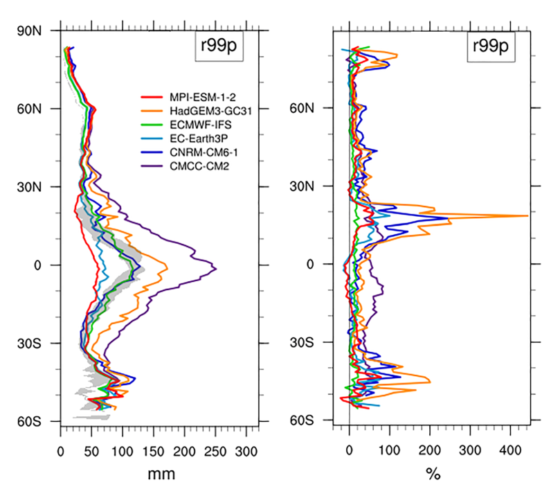
There are, however, important caveats. The spread among observations is both substantial and at least as large as inter-model differences, confounding quantitative model evaluation (see figure, left panel). In some cases, the match between low-resolution simulations and observational estimates is better than that of the high-resolution simulations. This underlines a key lesson: increasing resolution is not a panacea. This study provides evidence that increasing horizontal atmospheric resolution alone does not improve simulated extreme precipitation systematically. The benefits in some models may not be seen in others, where additional developments in model physics and tuning may be as, if not more, important. ♦
Author’s note
The climate models in this study participate in the sixth phase of the World Climate Research Programme’s Coupled Model Intercomparison Project (CMIP6), the modelling framework underpinning the Intergovernmental Panel on Climate Change’s Sixth Assessment Report. These model simulations (highresSST-present) were supported by the European Commission-funded PRIMAVERA project, the European contribution to HighResMIP, a CMIP6-endorsed and coordinated assessment of the impact of increasing model resolution, which is documented by Haarsma et al., 2016.
References
Bador, M. et al., 2020. Impact of Higher Spatial Atmospheric Resolution on Precipitation Extremes Over Land in Global Climate Models. Journal of Geophysical Research: Atmospheres 125, e2019JD032184.
Haarsma, R. J. et al., 2016. High Resolution Model Intercomparison Project (HighResMIP v1.0) for CMIP6. Geoscientific Model Development 9, 4185–4208.
